Hanoi unveils ambitious master plan for Red River landscape axis to redefine urban connectivity and flood management


The Hanoi People’s Committee has officially opened a public consultation period from September 7 to September 27, 2026, regarding a sweeping proposal to adjust the general urban zoning plan for the Red River landscape axis. This strategic initiative, scaled at 1:5,000, aims to transform the riverfront into a major socio-economic corridor that balances essential flood defense mechanisms with modern urban mobility and aesthetic development. By integrating land, water, and rail transport, the municipal government seeks to unify the capital’s fragmented riverfront infrastructure into a cohesive, world-class metropolitan backbone.
Strategic Infrastructure and Design Parameters
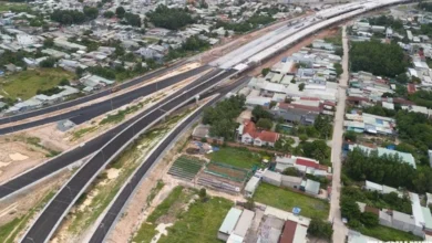
The heart of this development plan involves two primary arterial roads flanking the Red River: the Huu Hong (Right Bank) route and the Ta Hong (Left Bank) route. The Huu Hong road spans approximately 45.35 kilometers, while the Ta Hong route extends over 35 kilometers. Both are designed as high-capacity transit corridors featuring six main lanes capable of supporting speeds of up to 80 km/h, supplemented by four dedicated frontage roads with a speed limit of 60 km/h.
According to the Hanoi Institute of Construction Planning, the existing riverfront infrastructure is currently inadequate, consisting largely of fragmented rural roads ranging from 3.5 to 7 meters in width. These paths fail to accommodate modern heavy vehicle traffic and lack the necessary connectivity to the city’s broader road and rail network. The new master plan seeks to rectify this by integrating pedestrian walkways, cycling paths, and public transit nodes, effectively turning the riverfront into a "living room" for the city rather than a mere industrial or agricultural boundary.

Aligning with the 100-Year Vision
The proposed project aligns with Hanoi’s broader 100-year vision, which emphasizes a "polycentric urban cluster" model. Under this spatial framework, Hanoi acts as the central hub of a regional network, with satellite cities surrounding it to drive holistic economic growth. The Red River landscape axis is identified as one of nine critical development levers that will shape the capital’s spatial, aesthetic, and logistical future.
The plan prioritizes the seamless integration of road, rail, and maritime transport. Engineers have designed the corridors to harmonize with existing flood control dikes, ensuring that the new urban expansion does not compromise the city’s safety during monsoon seasons. The objective is to create a continuous, high-capacity flow along both sides of the river, linking the core city to peripheral districts and neighboring provinces.
Engineering Challenges and Solutions
A significant portion of the engineering focus is placed on maintaining the integrity of historical and environmentally sensitive sites. For instance, in the vicinity of the iconic Long Bien Bridge, designers have incorporated a 66-meter-wide underground tunnel to avoid disturbing the historic structure. Similarly, the segment of the Ta Hong road between the Bac Cau bridge head and the Thang Long bridge head has been optimized with a narrower 49.5-meter cross-section to protect local heritage sites while still providing six main traffic lanes and two service lanes.
The connectivity of the two banks will be facilitated by a network of 17 bridges. Of these, 12 are either existing or currently under construction, while five new bridges—Lien Trung, Tam Xa, Can Khoi, Bat Trang, and Khuyen Luong—are planned to bridge critical gaps. The junction designs follow a hierarchy of connectivity, prioritizing the integration of the city’s ring roads (1 through 4) with intermediate transit arteries to ensure efficient traffic flow for both private and public vehicles.

Public Transit and Maritime Integration
The master plan places heavy emphasis on public transport, aiming to synchronize the bus network with urban rail lines. Bus stops are planned at intervals of 300 to 500 meters, with a maximum distance of 800 meters to ensure accessibility. Furthermore, the municipal authorities intend to upgrade the river’s maritime infrastructure, converting traditional cargo ports into recreational tourism hubs. This transition is expected to foster the development of a river-bus system that connects scenic landmarks and historical sites along the 120-kilometer stretch of the Red River within Hanoi’s borders.
The rail network is also set for a significant overhaul. Eleven urban railway lines, including lines 1, 2, 4, 5, 6, 7, 8, 10, 14, 15, and 2A, will intersect with the riverfront axis, creating a multimodal transport network that reduces reliance on personal vehicles.
Implementation Timeline and Phasing
The project is structured into two distinct phases, spanning from 2026 to 2038.
- Phase 1 (2026–2030): This period focuses on the construction of the primary landscape axis, the stabilization of the riverbanks, and the development of essential public spaces, such as parks and the proposed urban residential areas in Linh Nam and Long Bien. During this time, the city will also prioritize the legal and financial frameworks necessary for land acquisition and site clearance.
- Phase 2 (2030–2038): The second phase will focus on the completion of the remaining project components, including secondary infrastructure, secondary bridges, and the full operational integration of the public transit nodes.
Socio-Economic Implications
Urban planning experts note that the success of this project hinges on the effective management of the land surrounding the Red River. By upgrading the riverfront, Hanoi stands to unlock significant land value, potentially creating thousands of hectares of prime real estate that can be used for public parks, cultural centers, and high-density mixed-use developments.

However, the project also presents challenges. Critics and urban analysts emphasize that the massive scale of the construction requires rigorous environmental oversight to prevent erosion and negative impacts on the river’s ecosystem. Furthermore, the displacement of existing settlements and the transition of agricultural land into urban zones will require a sensitive approach to social equity and compensation policies.
Official Response and Public Participation
The Hanoi People’s Committee has emphasized that the public consultation phase is a vital step in ensuring the project’s transparency and community acceptance. By soliciting feedback from residents, the city hopes to address concerns regarding environmental sustainability, traffic congestion, and the preservation of cultural heritage.
"The Red River is the soul of Hanoi," a representative from the municipal planning department stated during the project launch. "Our goal is not just to build roads, but to create a sustainable, vibrant, and resilient urban environment that serves the people of the capital for generations to come."
As the city enters this new phase of development, the Red River axis represents more than just a infrastructure project—it is a symbol of Hanoi’s modernization efforts. With the planned investment and strategic focus on long-term sustainability, the city is positioning itself to become a more integrated and efficient hub within the Southeast Asian region. The coming weeks of public consultation will likely be pivotal in refining the final details of this historic transformation.
Related posts: