The urban landscape surrounding Hoàn Kiếm Lake and its adjacent historic zones in Hanoi has recently drawn intense public scrutiny and expert debate following proposed local adjustments to the H1-1B urban sub-zone planning and a portion of the H1-1C sub-zone planning. As the municipal administration pushes forward with efforts to concrete long-term architectural visions, residents, urban planners, and heritage conservationists have actively engaged in public consultations, reviewing conceptual renderings that reshape the visual and spatial future of the capital’s core.
The discussion centers on how modern urban development initiatives intersect with centuries-old heritage. The proposed adjustments, officially approved in principle by the Hanoi People’s Committee, aim to operationalize broader strategic frameworks set forth in the capital’s overarching 100-year master plan. By translating macro-level directives into specific sub-zone guidelines, the city seeks to harmonize contemporary infrastructure needs with the preservation of historic landmarks, cultural assets, and ecological networks within the Inner Historic Quarter.
Understanding the Scope of Sub-Zone Planning Adjustments
Sub-zone planning serves as an essential bridge between master city planning and detailed localized design. According to Mr. Nguyễn Bá Nguyên, Deputy Director of the Hanoi Department of Construction, these sub-zone adjustments define specific land-use functions, area allocations, and regulatory parameters for each urban block. They establish the foundational requirements for spatial organization, architectural landscapes, and technical infrastructure.
Within these planning documents, urban design frameworks dictate critical parameters such as building height limits, setback lines, and visual corridors along primary thoroughfares and central squares. Furthermore, they designate open spaces, landmark structures, and overall architectural identities for targeted areas.
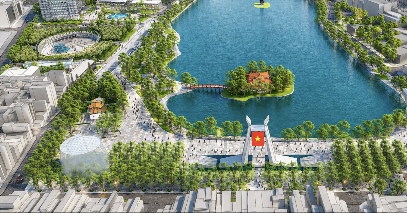
However, municipal authorities have repeatedly emphasized that conceptual illustrations and renderings released during public consultations should not be misconstrued as finalized architectural blueprints. Mr. Nguyên clarified that current visual materials are intended solely to demonstrate potential spatial relationships, public space networks, and landscaping directions. They do not represent final design choices or fixed construction forms for individual parcels of land.
The Chronology of the Planning Initiative and Public Consultation Process
The formal process of adjusting the H1-1B and H1-1C sub-zone planning stems from a sequence of administrative milestones aimed at updating Hanoi’s core urban management framework. On May 13, the Hanoi People’s Committee approved the directive to pursue localized adjustments to the sub-zones, aligning them with the overarching 100-year capital master plan vision.
Following this approval, the Department of Planning and Architecture, in collaboration with local district authorities, initiated public exhibition phases to display proposed renderings, zoning maps, and spatial frameworks. This transparent approach aligns with Vietnam’s Law on Urban and Rural Planning, which mandates community participation to harness public wisdom, expert insights, and civic responsibility.
During the consultation period, city agencies have collected feedback from various stakeholder groups, including heritage organizations, academic institutions, and local residents. Once the consultation window concludes, planning authorities are tasked with synthesizing public comments, conducting technical feasibility reviews, and incorporating appropriate recommendations into the master draft. Issues that cannot be directly integrated must be formally addressed and explained by the drafting agencies before the revised dossier is submitted to competent authorities for formal appraisal and final approval.
Balancing Heritage Preservation and Modern Urban Infrastructure
The core challenge facing the H1-1B sub-zone—which encompasses Hoàn Kiếm Lake and its immediate surroundings—lies in balancing rigorous heritage conservation with the demands of a modern, tourism-driven metropolis. The historic inner city serves as the cultural heart of Hanoi, containing dense layers of architecture reflecting Vietnamese dynastic history, French colonial influence, and post-independence urban evolution.
Under the current planning adjustments, new construction and renovation projects within the vicinity of Hoàn Kiếm Lake must strictly elevate landscape quality, protect cultural heritage, and enhance public utility. The city’s urban design guidelines prioritize the safeguarding of traditional architectural scales while improving urban infrastructure and environmental conditions.
A major focus of the proposed layout is the physical and visual integration of Hoàn Kiếm Lake with surrounding major public squares. These include Đông Kinh Nghĩa Thục Square, the Hanoi Grand Church Square, Lý Thái Tổ Square, the Hanoi Opera House Square, and the plaza fronting the King Lê Monument. Additionally, planners have proposed creating a expansive civic plaza directly in front of the headquarters of the Hanoi People’s Council and People’s Committee, significantly expanding green spaces and water surface elements within the historic center.

Expert Perspectives and the Debate Over Urban Symbols
The inclusion of conceptual visualizations for new urban symbols and architectural interventions near Hoàn Kiếm Lake has sparked considerable discourse among prominent architects, historians, and urban planning experts.
Associate Professor, Dr. Arch. Đào Ngọc Nghiêm, Vice President of the Vietnam Association for Urban Planning and Development, has underscored the necessity of building upon previous research and thoroughly acknowledging the full value of the existing heritage landscape. In recent statements, expert panels have advised caution regarding the introduction of new monuments, decorative elements, or structural symbols within the lake’s protective buffer zone, warning that even minor visual additions can disrupt the delicate balance of the natural and cultural landscape.
Experts argue that any physical intervention in the Hoàn Kiếm Lake area must be backed by rigorous scientific research, historical analysis, and comprehensive impact assessments. Because the lake holds profound symbolic value for both Hanoians and the nation as a whole, planning decisions must transcend standard municipal development metrics to account for intangible cultural heritage, collective memory, and psychological attachment.
Implications for Hanoi’s Future Development and Citizen Engagement
The ongoing planning adjustments for the H1-1B and H1-1C sub-zones represent a critical testing ground for participatory urban governance in Vietnam. As Hanoi navigates the complexities of rapid modernization, population growth, and booming tourism, the city government’s willingness to engage public feedback on sensitive heritage sites marks a progressive step in urban management.
The distinction between sub-zone planning guidelines and detailed 1/500 scale architectural designs is vital for managing public expectations. While sub-zone adjustments set the legal and spatial boundaries, subsequent design phases will offer further opportunities for specialized architectural competitions and rigorous reviews. This multi-layered planning structure ensures that initial conceptual images serve their true purpose: sparking constructive dialogue rather than dictating final outcomes.
Ultimately, the successful execution of these planning adjustments will depend on the municipal administration’s ability to synthesize diverse viewpoints, reconcile conflicting interests, and prioritize long-term public welfare over short-term commercial gains. By anchoring future developments in scientific rigor and deep respect for historical identity, Hanoi aims to secure a sustainable urban future that honors its storied past while meeting the evolving needs of its citizens and visitors alike.