Weather Update: Northern Vietnam Experiences Drier Conditions as Heavy Rains Shift Focus to Central and Southern Regions

The meteorological landscape across Vietnam is undergoing a distinct transition, marked by a notable reduction in rainfall across the northern provinces, while central and southern regions brace for severe weather events. According to the latest bulletins issued by the National Center for Hydro-Meteorological Forecasting, atmospheric dynamics are driving heavy to torrential downpours from Nghe An down to the southern provinces, including the Central Highlands. This shift in weather patterns has raised concerns regarding localized flooding, urban waterlogging, and hazardous conditions both inland and across maritime sectors.
As the persistent rain bands that previously affected northern Vietnam begin to dissipate, residents in the capital city of Hanoi and surrounding northern areas are experiencing a respite. While overcast skies and occasional scattered showers remain in the forecast, the overall precipitation volume has dropped significantly compared to earlier in the week. However, the scenario is drastically different as one moves southward. A convergence of monsoonal moisture, active tropical convergence zones, and low-pressure disturbances over the central maritime areas has set the stage for intense convective activity across a broad swath of the country.
Meteorological Context and Atmospheric Mechanisms
The heavy rainfall currently impacting central and southern Vietnam is primarily driven by a combination of seasonal tropical weather systems. Forecasters highlight that an active intertropical convergence zone, interacting with a low-pressure area currently hovering over the middle region of the South China Sea, is generating strong wind shear and high moisture transport. This atmospheric setup continuously feeds rain clouds into the coastal and inland areas of central and southern Vietnam.
In maritime zones, particularly across the middle of the South China Sea, these converging systems have produced strong winds and rough seas, prompting warnings for maritime vessels operating in the region. Navigational safety advisories have been issued for fishermen and commercial shipping lanes as choppy waters and reduced visibility accompany the squalls.
Regional Forecast Breakdown: Central Vietnam on High Alert
The Central region, stretching from Nghe An down to Thua Thien Hue, is bearing the brunt of the current weather system. Heavy to very heavy rainfall, accompanied by thunderstorms, has been recorded across multiple provinces.
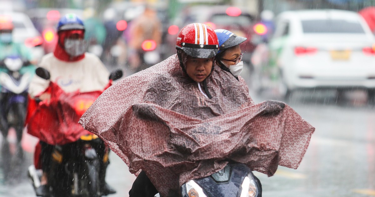
Between September 18 and September 19, localities from Nghe An to Hue experienced moderate to heavy rain, with cumulative precipitation widely ranging between 30 millimeters and 60 millimeters. In several localized areas, rainfall has exceeded 80 millimeters within a compressed timeframe, triggering flash flood warnings for small streams and landslide risks in mountainous terrains. Meteorological models indicate that rainfall intensities could surpass 80 millimeters within a three-hour window in vulnerable zones.
As the weather disturbance progresses through September 19 and 20, the heavy rain belt is forecast to consolidate over the region spanning from Ha Tinh to Hue, alongside parts of the Central Highlands and southern provinces. Rainfall amounts in these sectors are expected to average between 20 millimeters and 40 millimeters, with isolated spots receiving over 70 millimeters. Local authorities have been urged to maintain high vigilance, especially in low-lying residential areas and slip-prone mountain passes.
Southern Vietnam and Ho Chi Minh City Face Prolonged Downpours
In the southern provinces and Ho Chi Minh City, the ongoing rainy season has intensified due to the broader regional weather convergence. Comprehensive forecasts for the 48-hour period from 1:00 PM on September 18 to 1:00 PM on September 20 point toward persistent moderate to heavy rain, with severe downpours expected in several districts.
Ho Chi Minh City, in particular, is bracing for significant water accumulation. Total rainfall accumulations across the municipal area are projected to range between 70 millimeters and 150 millimeters over the 48-hour duration, with specific localized gauges potentially exceeding 150 millimeters. Given the city’s complex drainage infrastructure and susceptibility to tidal influences, municipal authorities have implemented contingency measures to manage urban flooding during peak downpour periods. Commuters have been advised to monitor traffic updates and avoid historically flood-prone thoroughfares.
Across the wider Southern region, cumulative rainfall is forecast to scale between 80 millimeters and 150 millimeters, with extreme downpours peaking above 170 millimeters in isolated sectors. These intense bursts of rain carry the inherent risk of localized flash floods, lightning strikes, and strong gusts of wind that could disrupt daily activities, damage temporary infrastructure, and impede vehicular traffic.
Detailed Weather Outlook Across Vietnam’s Regions
To provide a comprehensive overview for travelers and local residents, national forecasters have released a detailed regional breakdown for the day:
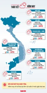
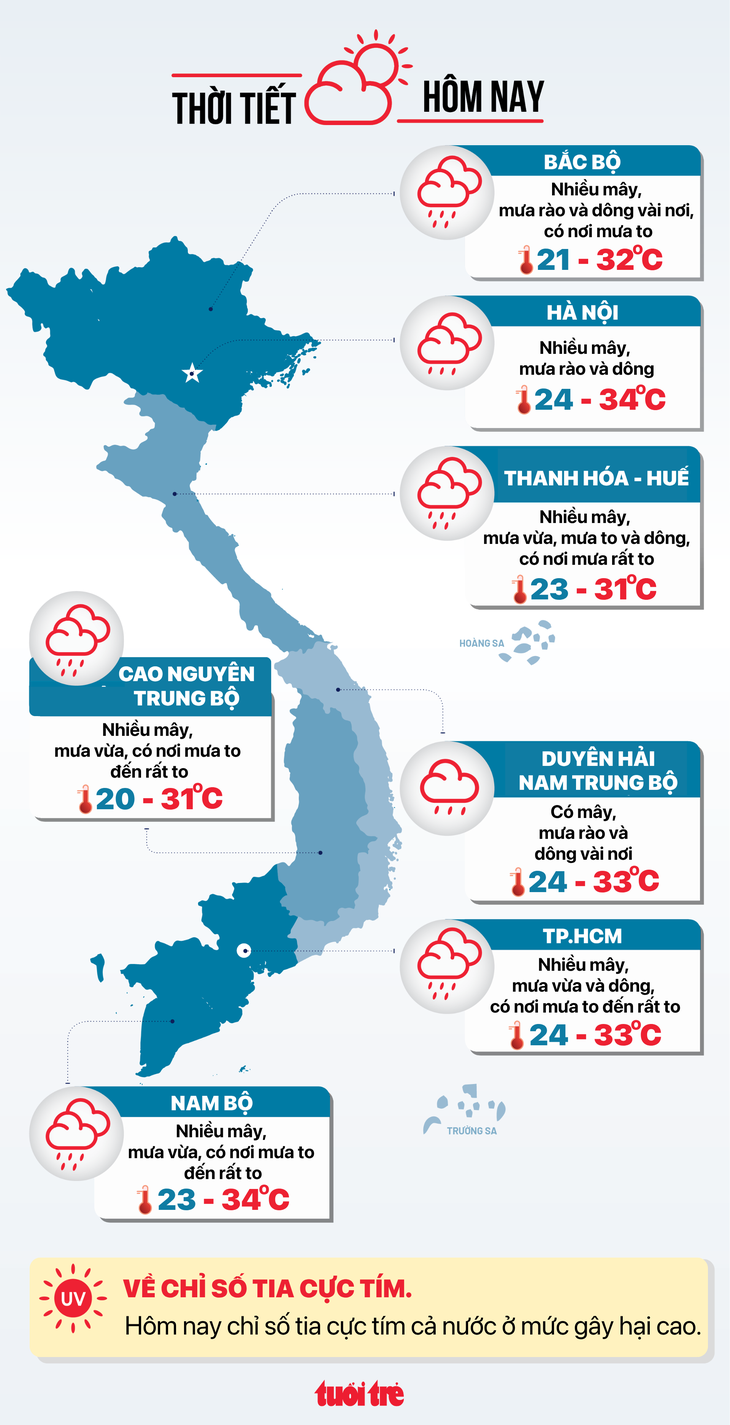
Hanoi: The capital city remains mostly cloudy with intermittent rain showers and thunderstorms. Temperatures are expected to range from a comfortable low of 24-26°C to a high of 32-34°C, offering a slight cooling trend compared to previous weeks.
Northwestern Vietnam: Cloud cover will dominate the region, accompanied by scattered rain showers and isolated thunderstorms. Morning and evening temperatures will remain mild, with lows between 21-25°C and daytime highs reaching 29-32°C.
Northeastern Vietnam: Similar to the capital, the northeastern provinces will see cloudy skies with scattered showers. Notably, the southern plains and southern parts of Phu Tho province face a higher probability of heavy downpours. Temperatures will fluctuate between 22-26°C overnight and peak at 30-33°C during the afternoon.
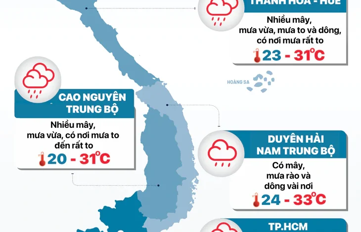
North-Central and Central Coastal Region (Thanh Hoa to Hue): This region remains under severe weather alerts, experiencing continuous moderate to heavy rain, thunderstorms, and localized torrential downpours. Temperatures are relatively subdued due to cloud cover and precipitation, registering lows of 23-26°C and highs of 28-31°C.
South-Central Coastal Region: Partly cloudy skies prevail with only isolated rain showers and thunderstorms. Daytime conditions remain warm, with lows ranging from 24-27°C and highs reaching 30-33°C.
Central Highlands (including Lam Dong): High humidity and cloud cover will trigger significant afternoon and evening downpours. Certain areas, particularly within Lam Dong province, are expected to record very heavy rainfall. Nighttime temperatures will drop to a crisp 20-23°C, while daytime highs will hover around 28-31°C.
Southern Vietnam and Ho Chi Minh City: Extensive cloud cover will persist throughout the day, bringing widespread moderate to heavy rain and thunderstorms. Heavy to very heavy downpours are expected in several areas. Temperatures will range from 23-26°C at night to 31-34°C in the afternoon across the region, while Ho Chi Minh City specifically expects temperatures between 24-26°C and maximums of 30-33°C.
Implications and Disaster Risk Management
The transition from northern dryness to central and southern heavy precipitation underscores the dynamic and often unpredictable nature of Vietnam’s seasonal transition periods. Hydrological experts emphasize that while rainfall provides essential moisture for agricultural sectors and replenishes reservoirs, the rapid concentration of high-volume water over short periods poses significant societal and economic risks.
Urban centers like Ho Chi Minh City face recurring challenges with surface water management. Rapid urbanization and the reduction of natural permeable surfaces continue to exacerbate urban flooding during intense cloudbursts. Municipal drainage companies have been placed on standby to operate pumping stations and clear blocked drainage grates promptly.
In rural and mountainous areas, the primary hazards stem from soil saturation. Consecutive days of rainfall increase the susceptibility of slopes to landslides and flash floods, threatening rural communities, infrastructure, and transport networks. Local disaster prevention steering committees across central provinces and the Central Highlands have activated emergency protocols, advising residents in high-risk zones to remain alert, secure their properties, and comply with evacuation orders if issued by local authorities.
As maritime operations face headwinds from rough seas in the middle of the South China Sea, port authorities and coastal management boards are strictly monitoring vessel movements. Boats operating outside safe harbors are advised to seek shelter or alter courses to avoid turbulent waters.
Looking ahead, meteorological agencies will continue to track the evolution of the tropical low-pressure system and its associated convergence bands. Public advisories are being updated regularly across official national weather portals to ensure timely dissemination of data, empowering communities to mitigate weather-related risks effectively as the situation unfolds.