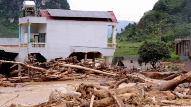
Weather Alert: Northern Vietnam Welcomes Early Cold Air Mass While Central and Southern Regions Face Severe Torrential Rains


The national hydrometeorological forecasting center has reported significant shifts in weather patterns across Vietnam as an early-season cold air mass descends upon the northern provinces. This atmospheric disturbance, interacting dynamically with converging tropical moisture, active southwesterly monsoonal winds, and various other regional climatic systems, has triggered a complex weather event characterized by morning thunderstorms in the north and prolonged, intense rainfall spanning the central and southern regions. Meteorological experts are closely monitoring these developments, particularly as concurrent oceanic disturbances over the East Sea raise concerns regarding potential tropical depression and storm formations.
The onset of this early autumn cold front marks a notable transition in seasonal patterns across northern Vietnam. On September 11, the northern provinces found themselves firmly under the influence of this continental cooling system. The early morning hours across the region were marked by scattered showers and thunderstorms, with localized heavy downpours disrupting morning routines. However, as the day progressed into late morning and afternoon, the precipitation over the northern region gradually dissipated, giving way to clear skies and sunshine. Maximum temperatures peaked at a comfortable 29 to 31 degrees Celsius, providing a temporary respite from the lingering summer humidity, though nighttime and early morning lows dropped to a crisp 22 to 25 degrees Celsius, particularly in mountainous and high-altitude areas.
For the capital city of Hanoi, the weather on September 11 followed a similar trajectory. Morning commuters navigated through localized showers and sporadic thunderstorms, accompanied by heavy downpours in certain districts. Daytime temperatures hovered between 30 and 31 degrees Celsius, while nighttime lows settled comfortably around 22 to 25 degrees Celsius. Meteorological projections indicate that this cooler nocturnal temperature regime will persist through approximately September 12, after which a gradual warming trend is anticipated as the cold air mass slowly modifies and loses its initial intensity.
Comprehensive Regional Breakdown and Precipitation Forecasts
While the north experiences a relatively benign transition toward cooler conditions, the central, central highlands, and southern regions of Vietnam are confronting a severe and prolonged heavy rain event. The combination of the southward-migrating cold air mass, active low-pressure troughs, and persistent southwesterly winds has established a multi-layered weather hazard that poses significant risks to local infrastructure, agriculture, and public safety.

According to detailed regional forecasts issued by meteorological authorities, the weather distribution across the country on September 11 and subsequent days is categorized as follows:
Hanoi: Expect cloudy skies with morning rain showers and thunderstorms, accompanied by localized heavy downpours. Winds will blow from the northeast at level 2 to 3. Residents are advised to remain vigilant against potential lightning, hail, and strong gusts during thunderstorms. Minimum temperatures will range from 22 to 24 degrees Celsius, with maximum temperatures reaching 29 to 31 degrees Celsius.
Northern Vietnam (Northwest and Northeast): Cloudy conditions will prevail with morning rain showers and thunderstorms, turning to scattered showers later in the day. Mountainous areas may experience localized heavy downpours. Winds will remain generally light, except near coastal areas where northeasterly winds may reach level 3. Minimum temperatures in high-altitude zones could drop below 20 degrees Celsius, while daytime highs will generally range from 28 to 31 degrees Celsius.
Thanh Hoa to Hue: The northern sector, encompassing Thanh Hoa and northern Nghe An, will experience scattered showers and thunderstorms with localized heavy rain. Meanwhile, the southern sector faces continuous moderate to heavy rainfall accompanied by thunderstorms, with some areas receiving very heavy downpours. Winds will blow from the north to northwest at level 2 to 3, posing risks of squalls and lightning. Temperatures will range from a low of 22 to 25 degrees Celsius to a high of 28 to 31 degrees Celsius.
South Central Coast: The northern portion of this region, stretching from Da Nang to eastern Quang Ngai, is bracing for widespread moderate to heavy rain and thunderstorms, with exceptionally heavy rainfall totals in isolated pockets. The southern portion will experience scattered showers and thunderstorms. Prevailing southwesterly winds will maintain speeds of level 2 to 3. Temperatures will remain relatively stable, ranging between 22 and 25 degrees Celsius overnight and 28 to 31 degrees Celsius during the day.

Central Highlands: Heavy rainfall continues to dominate the plateau region, with widespread moderate to heavy downpours and embedded thunderstorms. Accumulations are expected to be significant, accompanied by strong southwesterly winds at level 2 to 3. Nighttime temperatures will drop to a cool 20 to 23 degrees Celsius, while daytime highs will struggle to reach 26 to 29 degrees Celsius due to persistent cloud cover and precipitation.
Southern Vietnam and Ho Chi Minh City: The southern provinces and the economic hub of Ho Chi Minh City are experiencing persistent moderate to heavy rain, thunderstorms, and localized very heavy downpours. Southwesterly winds at level 2 to 3 will dominate, with heightened risks of severe thunderstorms producing lightning, hail, and strong wind gusts. Temperatures in Ho Chi Minh City will range from a low of 24 to 26 degrees Celsius to a high of 29 to 31 degrees Celsius.
Escalating Risks and Multi-Day Rainfall Accumulations
The hydrometeorological agency has underscored the severity of the ongoing precipitation event, highlighting specific accumulation thresholds and high-risk timeframes for the central and southern provinces.
During the daytime hours of September 11, regions stretching from southern Nghe An to Da Nang, along with eastern Quang Ngai and the Central Highlands, are recording widespread rainfall totals of 20 to 40 millimeters, with isolated areas exceeding 100 millimeters. The situation is even more critical in the southern region, where rainfall totals are averaging 20 to 60 millimeters, and localized spots are surpassing 120 millimeters.
As the weather system intensifies moving into the night of September 11 and throughout September 12, the core of the heavy rainfall is projected to shift and concentrate over the corridor from Ha Tinh to Da Nang and eastern Quang Ngai. Forecasters anticipate general rainfall accumulations of 40 to 80 millimeters during this window, with extreme downpours exceeding 150 millimeters in localized areas.

Furthermore, the Central Highlands and southern provinces will continue to endure moderate to heavy rain, with common totals ranging from 30 to 60 millimeters and localized peaks surpassing 100 millimeters. Authorities have issued specific warnings regarding high-intensity rainfall rates capable of exceeding 100 millimeters within a compressed three-hour window, greatly elevating the risk of flash flooding in urban areas.
The most critical period for the central coastal region is forecasted to unfold from the night of September 12 through September 13. During this 48-hour window, provinces from Quang Tri down to Da Nang and eastern Quang Ngai will face torrential downpours and scattered thunderstorms, with cumulative rainfall expected to range between 50 and 100 millimeters, and localized extremes potentially exceeding 200 millimeters. Meteorological models suggest that this heavy rainfall episode in central Vietnam has the potential to linger, exhibiting a complex and prolonged evolution that requires continuous monitoring.
Broader Meteorological Context and Maritime Hazards
This late-summer and early-autumn weather anomaly is occurring against a backdrop of complex large-scale climatic drivers. The early arrival of the northern cold air mass has compressed the intertropical convergence zone, creating an atmospheric environment highly conducive to convective activity across the country.
Simultaneously, maritime monitors have identified a developing low-pressure area over the East Sea (South China Sea). Meteorological agencies indicate a moderate to high probability that this low-pressure system could intensify into a tropical depression or even develop into a named tropical storm in the coming days. The interaction between this maritime disturbance and the continental cold front creates a high degree of forecasting uncertainty, raising concerns among maritime authorities regarding safety operations for vessels operating in the East Sea.
In the southern half of the country, long-term climate projections add another layer of complexity. Climatologists analyzing the progression of the El Nino phenomenon for the 2026–2027 cycle warn that peak intensity phases could lead to an early conclusion of the rainy season across Ho Chi Minh City and the broader southern delta. While the immediate concern is excessive moisture and severe flooding, the longer-term outlook points toward potential severe drought conditions, agricultural water stress, and intensified saltwater intrusion in the Mekong Delta once the dry season sets in.

Official Advisories, Disaster Preparedness, and Mitigation Measures
In response to the multi-regional weather hazards, national and local disaster management authorities have activated emergency preparedness protocols. State agencies have issued comprehensive warnings to local populations, urging residents in mountainous and low-lying areas to remain highly alert to the compounding risks of flash floods along small rivers and streams, rain-induced landslides along steep slopes, and severe urban inundation.
Local municipal governments, particularly in central and southern provinces prone to torrential downpours, have been directed to inspect vulnerable residential clusters, reinforce infrastructure, and prepare evacuation plans for communities situated in high-risk landslide zones. Disaster response teams remain on standby to deploy rescue equipment and provide immediate relief in the event of severe flooding or isolation caused by washed-out roads and compromised bridges.
For the maritime sector, port authorities and fishing vessel operators plying the waters of the East Sea have been instructed to monitor weather bulletins closely, secure moorings, and avoid navigating into zones impacted by active squall lines, high winds, and rough seas associated with the developing low-pressure system.
As Vietnam navigates this volatile transition period between seasonal regimes, coordinated disaster response efforts and timely meteorological updates remain essential to mitigating risks, protecting agricultural assets, and safeguarding public safety across all affected provinces.
Related posts: