Hanoi unveils ambitious master plan for Red River urban district featuring 109-story landmark tower

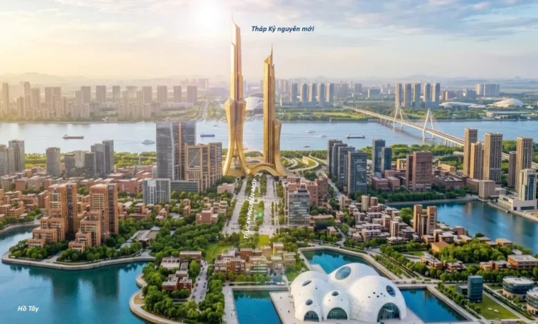
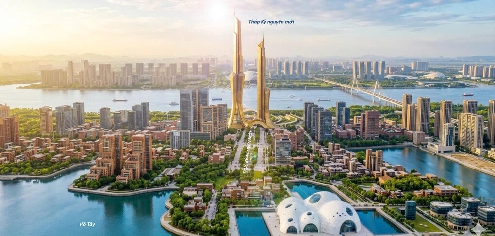
Hanoi’s vision for its future is shifting toward the riverfront as the municipal government officially launched a 20-day public consultation period on September 7, 2026, regarding the 1/5,000 scale master plan for the Red River urban district. At the heart of this transformative project lies a proposed 109-story landmark structure, dubbed the "Era Tower," which is set to become a defining feature of the city’s skyline and a cornerstone of the new urban core.
The master plan, covering a 40-kilometer stretch of the Red River, aims to reshape the capital’s relationship with its primary waterway, transitioning it from a historical boundary into the central "urban living room" of the city. By focusing on sustainable development, high-end infrastructure, and cultural integration, authorities hope to propel Hanoi into a new era of modern urbanism while preserving its historical legacy.
Project Scope and Geographical Context
The study area for the master plan extends 40 kilometers in a northwest-southeast direction, spanning from the Thang Long Bridge to the Thanh Tri Bridge. This corridor passes through the administrative boundaries of 16 communes and wards, effectively placing the river at the center of the capital’s central business district.
The plan categorizes the riverfront into three distinct sections, each defined by the existing bridges that cross the Red River. These bridges act as spatial boundaries, helping to structure the urban flow and define the character of each section.
- Section 1 (Hong Ha Bridge to Thang Long Bridge): This zone is dedicated to ecological conservation and natural landscape protection. It will house specialized parks, sports facilities, and extensive green belts to maintain the river’s natural biodiversity.
- Section 2 (Thang Long Bridge to Thanh Tri Bridge): This is the focal point of the development, designated as the "urban living room." It is envisioned as a high-density area featuring financial and commercial service centers, creative hubs, and iconic architectural landmarks.
- Section 3 (Thanh Tri Bridge to Me So Bridge): This southern segment focuses on commercial services, logistics, and eco-agricultural parks, aiming to bridge the gap between urban development and rural-style landscape experiences.
The Era Tower: A Symbol of Modernity
The 109-story Era Tower serves as the anchor for the central section. According to the Hanoi Institute of Construction Planning, the tower is designed to stand as a testament to the city’s rapid development and its long-term vision for the next century.
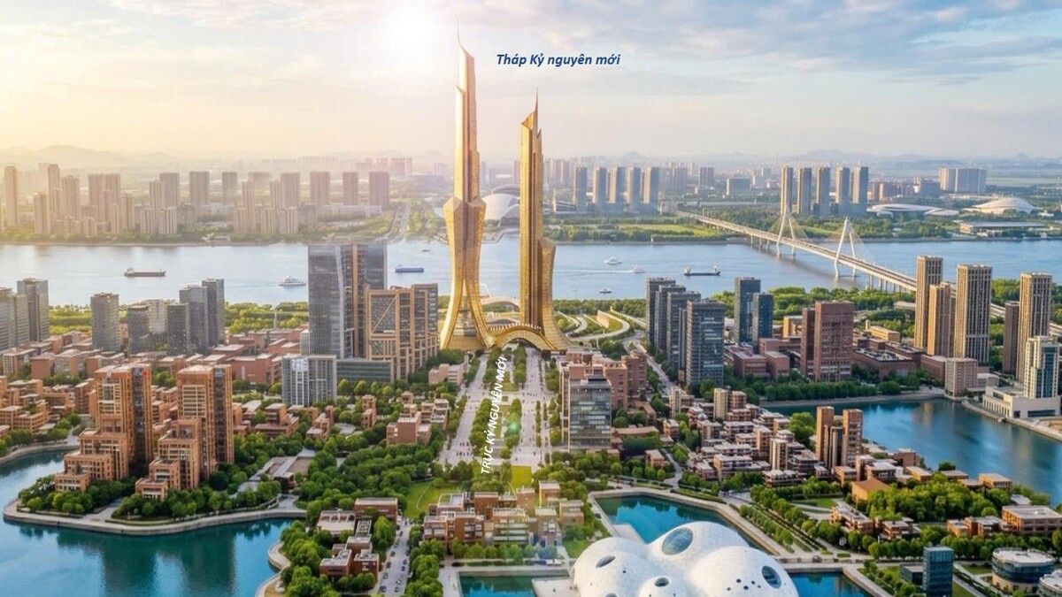
Architecturally, the building is positioned to harmonize with the nearby West Lake and Co Loa areas, creating a visual link between the ancient heritage sites and the futuristic urban developments. The tower is not merely a commercial asset; it is intended to function as a beacon of modernity, providing a high-profile location for international business, premium tourism, and state-of-the-art facilities that could attract global investment.
Strategic Planning and Zoning Breakdown
The master plan proposes a dense, high-utility land-use strategy. Of the total allocated land area:
- 60% is dedicated to public services and commercial infrastructure.
- 35% to 40% is reserved for residential development, incorporating modern living standards.
- 25% is allocated for specialized parks, and 5% for public parks.
Notably, the plan includes provisions for the preservation of traditional villages, with new residential projects in these areas limited to a height of three stories. This integration seeks to balance the scale of the new "Era" architecture with the intimate, historic fabric of Hanoi’s long-standing communities. The overall structural heights for the new urban zones are set between 30 and 45 stories, ensuring a varied skyline that avoids overwhelming the landscape.
Chronology and Development Roadmap
The Red River urban development is part of a broader vision for Hanoi’s growth over the next 100 years. The city has identified nine key development axes, with the Red River landscape corridor serving as the primary anchor for the initial phase.
- September 2026: Launch of the public consultation period to gather feedback from citizens and experts.
- Post-Consultation: Synthesis of public feedback followed by adjustments to the 1/5,000 scale master plan.
- Phase 1 Implementation: Focused development of the central section between Hong Ha Bridge and Me So Bridge, establishing the primary economic and urban framework.
- Phase 2 Expansion: Extension of the development to the western and southern urban boundaries, integrating with neighboring regions such as Thuong Tin, Phu Xuyen, and Van Giang (Hung Yen province).
This multi-phase approach is designed to ensure that development is manageable and that the required infrastructure, including bridge networks and cross-river transport, can be scaled appropriately.
Official Stance and Environmental Considerations
The Hanoi municipal government has emphasized that the plan is built on a foundation of "respect for nature." Planners argue that the project will actively reduce the negative impact of urban sprawl by concentrating development in specific, high-capacity zones.
A critical priority throughout the planning process has been flood control and safety. The city has reaffirmed that all construction must adhere strictly to the approved flood management and dike protection plans. The development utilizes the natural topography to ensure that, even with high-density urban areas, the city maintains sufficient space for flood drainage and emergency evacuation, adhering to the stringent standards required for a city situated on a major river system.
Broader Economic and Urban Impact
The implications of this plan are significant. By shifting the city’s center of gravity toward the Red River, Hanoi is effectively doubling the amount of prime urban real estate available for growth. This is expected to relieve the pressure on the current, highly congested inner city and provide a modern, sustainable alternative for residential and commercial expansion.
Economically, the creation of a "Financial and Service Core" in Section 2 is expected to attract significant Foreign Direct Investment (FDI). Analysts suggest that by creating a high-end, purpose-built urban center, Hanoi can compete more effectively for regional headquarters and international trade events. Furthermore, the integration of high-speed transport links across the river will likely catalyze growth in the southern districts of the city, such as Thuong Tin and Phu Xuyen, which have historically been less integrated into the city’s core economy.
Challenges and Future Outlook
Despite the ambitious vision, the project faces hurdles, particularly regarding public sentiment and the logistics of large-scale construction in a flood-prone area. Critics and citizens during the public consultation phase are expected to raise concerns regarding the impact on existing communities and the potential for increased traffic congestion.
However, the Hanoi Institute of Construction Planning maintains that the 1/500 scale detailed plans, which will follow the current 1/5,000 master plan, will address these concerns with surgical precision. The city’s goal is to create a "Blue-Green" urban model where water management and urban life coexist.
As the consultation period progresses, the government remains committed to balancing the need for rapid modernization with the preservation of the cultural and environmental identity of the Red River. If successful, the plan will not only redefine the skyline of Hanoi but will also establish a new standard for river-centric urban development in Southeast Asia.