Hanoi Experts Urge Cautious Urban Planning and Narrower Riverside Roads Along the Red River to Protect Local Communities and Ecology


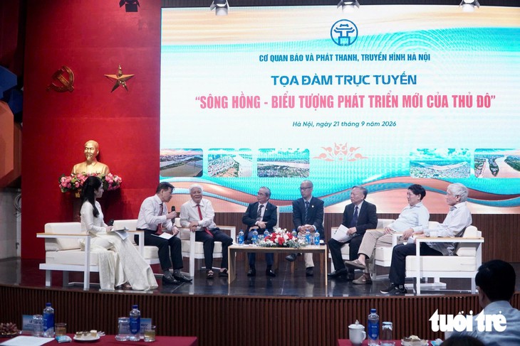
Hanoi’s aspirations to turn its urban landscape toward the Red River have entered a critical phase of debate, as urban planners, architects, and scientists gathered in the capital to reevaluate infrastructure strategies for the city’s most iconic waterway. Held on the afternoon of September 21 by the Hanoi Agency of Press and Broadcasting, a high-profile symposium titled "The Red River: A New Symbol of Capital Development" brought to light serious concerns regarding proposed massive road networks along the riverbanks. While transforming the Red River into the focal point of Hanoi’s socioeconomic and cultural life has long been a strategic goal, experts warn that over-engineering the waterfront could inadvertently sever the historic bond between the city’s inner districts and the river itself.
The core of the discussion centered on current proposals to construct expansive multi-lane roadways—ranging from 54 to 73 meters in width—along the outer dikes of the Red River. Architects and urban researchers argue that such colossal infrastructure projects risk acting as physical and psychological barriers, isolating urban residents from the water and contradicting the overarching policy of reconnecting Hanoi to its natural flow.
The Pitfalls of Over-Sized Infrastructure and Urban Fragmentation
Architect Tran Minh Tuan, representing the Hanoi Water Surface Space research group, pointed out a fundamental flaw in historical and current approaches to waterfront planning. While grand visions frequently emphasize turning the city toward the river, the practical execution often neglects pedestrian accessibility and community integration.
"Currently, we have a riverbank that residents cannot easily access," Mr. Tuan stated during the symposium. "External transportation systems remain limited, making the connection between the inner city and the riverfront inconvenient."

Mr. Tuan raised particular alarms regarding the proposed wide cross-section roads in the Red River’s outer-dike areas. The existing dikes already create a stark topographical division between the inner city and the riverbanks. Introducing an additional roadway spanning up to 73 meters—comparable to or wider than Hanoi’s bustling Ring Road 3—would effectively create a concrete moat, cutting off pedestrian flow and community interaction.
"If we introduce a heavy-duty, high-capacity transportation system of 10 to 12 lanes, equivalent to or wider than the current Ring Road 3, the fragmentation between inner Hanoi and the Red River will become an even more pressing issue," Mr. Tuan warned. He advocated instead for a fine-grained network of interconnected, multi-modal transport options, such as low-speed public transit, elevated light rail, bicycle lanes, and pedestrian pathways.
True waterfront integration, experts argue, goes beyond merely lining the banks with apartment towers or commercial blocks. It requires designing an urban fabric that invites millions of Hanoi residents to frequent the riverbanks for recreation, cultural activities, and daily life, ensuring they can tangibly feel the pulse of the river.
Navigating Climate Change and the Extreme Hydrological Regime of the Red River
Beyond traffic logistics, the symposium underscored a non-negotiable physical reality: the Red River possesses a volatile hydrological regime that sets it apart from typical urban rivers seen in other global metropolises.
While many international cities successfully commercialize stable, tranquil waterfronts, the Red River experiences dramatic seasonal fluctuations. Water levels can drop as low as 1 to 2 meters during the dry season, but surge up to 10 to 10.5 meters during peak flood periods—a vertical rise equivalent to a three-story building. Although the river features a distinct dry season, rising water levels can be sudden and severe.
"The fluctuations of the Red River are immense," Mr. Tuan emphasized. "Therefore, we must find a way to live in harmony with the river. This is a decisive prerequisite."
In the context of escalating global climate change, urban planning in Hanoi must transition from a mindset of absolute control to one of active adaptation. Applying rigid, sterile international urban models straight to the Red River without accounting for its natural flooding cycles is considered a recipe for disaster. Experts stress that future developments must respect the natural dynamics of the floodplain, balancing ecological resilience with urban expansion.
A Decades-Long Vision: Historical Context of Red River Development
The ambition to harness the landscape of the Red River and pivot Hanoi toward the water is far from a recent brainstorm. The strategic orientation for developing both banks of the river dates back to 1998, when the Prime Minister approved the Hanoi General Master Plan, widely known as the "108 Plan." At that time, the Red River was primarily designated as a green, open space corridor, focusing heavily on landscape preservation and minimal construction.
This vision was elevated in 2011 when the Prime Minister approved Decision 1259, greenlighting the General Construction Master Plan of Hanoi to 2030 with a vision toward 2050. Under this framework, the Red River was elevated from a mere green corridor to a central development symbol of the capital city.
However, translating this vision into reality has consistently collided with the complex realities of flood control and floodplain management. Architect To Anh Tuan, chairman of the Hanoi Urban Planning and Development Association and former director of the Hanoi Department of Planning and Architecture, noted that realizing the river’s potential depends entirely on mastering flood risks.

"Whenever we can manage and control the flood risks of the Red River, only then can we consider major shifts and development on the river flats," Mr. To Anh Tuan stated. "Only when we have viable plans for urban areas to coexist with the river’s natural flow can we truly fulfill this aspiration."
Preserving Traditional Villages and Cultural Heritage Amid Urbanization
For decades, Hanoi’s rapid urbanization has predominantly expanded toward the south and west, leaving the Red River corridor relatively untapped. With the recent approval of the Red River urban sub-zone master plan, municipal authorities have established a critical legal foundation for guiding future development. However, architects warn that as the grand landscape projects unfold, rigorous safeguards must be put in place to protect the fragile ecosystem of the alluvial flats, sandbars, and traditional river settlements.
Architect Pham Thanh Tung, chief office of the Vietnam Association of Architects, emphasized that the ongoing evolution of the river space must harmonize with nature rather than suffocating it under concrete structures.
"This is a project of vital importance," Mr. Tung said. "The vital transport routes must not crush the alluvial flats, village clusters, and sandbars. These are areas where the river breathes, where water seeps and is retained in the context of climate change. Therefore, waterfront development must follow a pro-nature, adaptive approach, rather than concentrating too many urban structures."
Mr. Tung outlined a multi-layered organizational model for the Red River space. The outer layers should consist of sandbars, agricultural flats, and riverbanks, while the inner layers accommodate the retrofitted urban zones. Building heights should gradually step down from the inside out, mirroring the natural topography of the river basin.

Crucially, the master plan must also safeguard the 12 historic craft villages and numerous archaeological relics and heritage sites embedded within the Red River corridor. "We must not erase history or culture during the process of development," Mr. Tung warned, urging authorities to maintain continuous dialogue with historians, researchers, and interdisciplinary experts.
Implications for Hanoi’s Future
The expert consensus emerging from the September 21 symposium sends a clear message to urban policymakers: while developing the Red River is essential for Hanoi’s evolution into a modern, globally competitive metropolis, speed and scale must not override ecological safety and human connection.
As Hanoi moves forward with the implementation of its Red River sub-zone master plans, balancing high-capacity mobility with pedestrian accessibility, respecting seasonal flood dynamics, and preserving centuries of cultural heritage will determine whether the Red River truly becomes a sustainable symbol of prosperity or a fractured barrier between the city and its life-giving stream.
Related posts: