Giant Storm Clouds Linger Over Ho Chi Minh City and Southern Provinces as Forecasters Warn of Prolonged Heavy Rains and Severe Flooding Risks


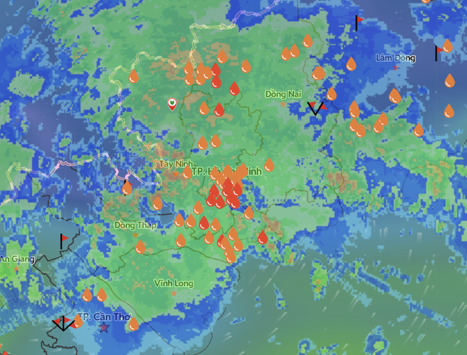
Ho Chi Minh City and the broader Southern region of Vietnam are bracing for a continuation of severe weather conditions after being battered by intense, relentless downpours. Following a brief afternoon lull that offered weary commuters a temporary window to navigate waterlogged streets during the evening rush hour, meteorological radar and satellite imagery have revealed that a massive convective storm system remains firmly anchored over the region. Weather authorities warn that the threat is far from over, with substantial rainfall expected to persist through the night and into the coming days, compounding urban infrastructure challenges, traffic gridlock, and the looming hazard of seasonal tidal surges.
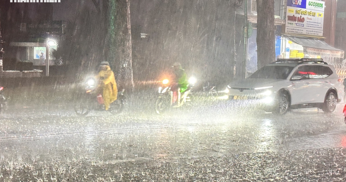
The current meteorological episode follows a torrential downpour that lasted for over two consecutive hours, paralyzing major transport arteries and plunging numerous low-lying residential and commercial zones into knee-deep water. According to real-time automated rain gauge networks managed by Vrain, precipitation levels skyrocketed by early evening on September 22, 2026. By 7:00 PM, at least seven distinct monitoring stations across Ho Chi Minh City recorded rainfall accumulations exceeding 100 millimeters. The highest localized volume was documented in Da Phuoc within Huong Long commune, where a staggering 142.4 millimeters of rain fell in a matter of hours. Similarly, the Co Bac station near the Ong Lanh Bridge registered 110.2 millimeters, illustrating the localized intensity of the convective cells that dumped massive sheets of water across the metropolitan area.
The deluge was not isolated to Vietnam’s southern economic hub. Neighboring provinces recorded comparable, if not heavier, downpours that overwhelmed local drainage infrastructure. In Dong Nai province, Minh Lap recorded 131 millimeters of rain, while Tan Trao in Tay Ninh province logged 109.2 millimeters. The agricultural heartland and coastal provinces were similarly impacted, with Go Cong in Dong Thap province measuring 110 millimeters, Cua Can in An Giang recording 155.8 millimeters, and Luong The Tran in Ca Mau province registering a torrential 180.6 millimeters. These widespread, high-intensity figures underscore the regional scale of the weather disturbance affecting the entire southern tip of the country.
Meteorological Origins and Atmospheric Drivers
According to the Southern Regional Hydrometeorological Center, the primary catalyst for this severe weather pattern is a robust active tropical convergence zone stretching across the south-central and southern regions of Vietnam. This atmospheric instability has been significantly amplified by a secondary meteorological phenomenon: a tropical depression disturbance originating in the South China Sea that has migrated inland, fundling immense volumes of atmospheric moisture directly over the mainland.
The convergence of these two powerful weather systems has created an ideal environment for the rapid formation of towering cumulonimbus clouds. These massive cloud structures possess high vertical development, producing not only torrential rainfall but also frequent lightning, deafening thunder, and strong, erratic wind gusts capable of snapping tree branches and tearing down unsecured signage. Meteorological models indicate that the peak of this current heavy rainfall episode is projected to persist through September 24, after which atmospheric pressure patterns are expected to shift, allowing rainfall volumes to gradually taper off beginning September 25.
Urban Vulnerability and the Compound Threat of Tidal Surges

The timing of these torrential downpours has severely exacerbated socio-economic disruptions across Ho Chi Minh City. Striking precisely during the peak evening commute, the sudden influx of water overwhelmed urban drainage systems, turning major boulevards into fast-flowing rivers. Thousands of motorists found themselves stranded mid-journey as rising waters stalled vehicle engines, forcing many to abandon their cars and motorbikes or seek temporary shelter under elevated walkways and business awnings. Public transport networks experienced severe delays, and ride-hailing services were temporarily suspended in deeply flooded sectors due to impassable roads.
Compounding the immediate crisis of heavy rainfall is the seasonal rising of tides across Ho Chi Minh City and the Mekong Delta. Hydro-meteorological experts note that regional tidal levels are currently on an upward trajectory, creating a dangerous hydrological bottleneck. When intense precipitation coincides with high tides, gravity-fed drainage systems fail completely, as the swollen canals and rivers cannot accept the runoff from the city streets. This dual hazard has significantly heightened the risk of prolonged, deep-seated inundation across industrial zones, residential neighborhoods, and major commercial districts, raising concerns over property damage, vehicular loss, and potential health hazards stemming from contaminated floodwaters.
Emergency Preparedness and Official Response
In response to the escalating weather alerts, municipal authorities and disaster management committees across Ho Chi Minh City and southern provinces have activated heightened emergency protocols. Local disaster response teams, traffic police, and urban drainage companies have been deployed to critical intersections, known flooding hotspots, and canal banks to assist stranded citizens, clear blocked drainage grates of accumulated debris, and manage traffic flow around submerged roadways.
City officials have issued urgent advisories urging residents to limit non-essential travel during forecasted heavy downpour windows, particularly during high-tide cycles. Motorists have been strongly cautioned against attempting to drive through deep floodwaters to prevent vehicle immobilization and personal safety risks. Furthermore, structural engineers and local authorities have reminded residents in older or vulnerable residential buildings to secure loose roofing materials and stay clear of large trees and electrical infrastructure during periods of severe lightning and violent wind gusts.
Outlook and Broader Implications
As southern Vietnam navigates this severe meteorological event, the situation highlights the growing vulnerability of rapidly urbanizing delta regions to extreme weather anomalies. Climate analysts emphasize that while the active tropical convergence zone and incoming maritime moisture depressions are seasonal occurrences, the intensity and frequency of such heavy rainfall events demand long-term infrastructure adaptation.
The immediate priority remains public safety and flood mitigation through the remainder of the peak period ending September 24. However, urban planners and regional policymakers are increasingly recognizing the necessity of accelerating major flood-control projects, expanding retention basins, and upgrading pumping stations to safeguard the region against the compounding threats of torrential precipitation and rising sea levels in the years ahead.