Hanoi Unveils Ambitious 737,000 Billion VND Red River Urban Landscape Master Plan to Transform the Capital by 2038

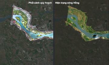
The Hanoi People’s Committee has officially unveiled a comprehensive urban planning initiative aimed at reshaping the landscape along both banks of the Red River. With an estimated investment of 737,000 billion VND, this project—projected to span until 2038—represents one of the most significant infrastructure and urban development undertakings in the history of Vietnam’s capital. By integrating modern urban design with environmental preservation, the master plan seeks to create a new iconic identity for Hanoi, characterized by expansive public parks, contemporary residential districts, and high-tech commercial hubs.
A New Vision for the Red River
The Red River has long been the lifeblood of Hanoi, yet for decades, the areas bordering the river have remained largely underdeveloped or characterized by informal, dense village settlements. The new master plan aims to bridge this gap by converting these riparian zones into a vibrant, sustainable, and flood-resilient urban core.
The strategy focuses on the section of the Red River extending from the Hong Ha Bridge to the Me So Bridge. This stretch is envisioned as a "green artery" for the city, where the interplay between water management and urban expansion is carefully balanced. Key components of the plan include the construction of advanced flood-control systems, the integration of Transit-Oriented Development (TOD) hubs, and the creation of dedicated spaces for educational, medical, and service-oriented infrastructure.
The Chronology of Development
The journey toward this monumental plan began several years ago, as the city recognized the urgent need for a cohesive urban framework to manage rapid population growth and urban sprawl. Following extensive surveys and technical studies, the municipal government published the 1/5000 scale zoning plan in September 2026. This release served as a formal solicitation for public feedback, marking a pivotal moment in the democratic process of urban planning.
The project is currently in the foundational phase, which involves:
- Data Collection and Mapping: Mapping of existing informal settlements, infrastructure bottlenecks, and environmental constraints.
- Public Consultation: Engaging with residents living in the affected zones to ensure transparency in relocation and resettlement policies.
- Technical Adjustment: Utilizing advanced geospatial tools to refine the boundaries of the 12 primary village clusters targeted for improvement or relocation.
Addressing the Human Element: Village Restructuring
A significant portion of the plan addresses the "village cluster" (cum lang) segments. The urban planning authorities have categorized these settlements into four distinct intervention tiers:
- Rehabilitation and Upgrading: Improving existing infrastructure in village clusters that are deemed stable and consistent with the long-term master plan.
- Partial Relocation: Reducing the density of specific areas to make room for public infrastructure, such as green corridors or flood-mitigation zones.
- Comprehensive Relocation: Moving residents from high-risk flood zones or areas designated for major infrastructure development.
- Resettlement Zones: Constructing modern, high-density residential complexes equipped with essential amenities, including schools and medical clinics, to accommodate those relocated under the plan.
The technical complexity of this task is evidenced by the "Adjustment Panel" mechanisms introduced by city planners, which allow for the precise adjustment of latitude and longitude markers for each village cluster. This digital-first approach to urban planning ensures that the physical transformation of the landscape is grounded in precise, verifiable data.
Economic and Infrastructure Implications
The scale of the 737,000 billion VND investment underscores the government’s commitment to transforming Hanoi into a globally competitive city. The development of Transit-Oriented Development (TOD) zones is particularly critical. By placing residential, service, and commercial hubs within close proximity to public transit nodes, the city hopes to alleviate traffic congestion—a long-standing challenge for the capital—and reduce the reliance on private vehicles.
Furthermore, the integration of new healthcare and educational facilities directly into the riverfront districts aims to decentralize public services. This is expected to relieve the pressure on the inner city, where population density has reached unsustainable levels.
Official Stance and Public Feedback
While the master plan is ambitious, it has not been without its challenges. The Hanoi People’s Committee has emphasized that the current planning maps serve as a reference point and may require fine-tuning based on the "ground truth" of existing structures.
The recent public consultation process highlighted concerns regarding the social impact of relocating long-standing communities. In response, city officials have stated that the resettlement policy will prioritize the preservation of social cohesion. Residents who are moved are to be provided with housing in modern, well-serviced urban areas that offer a higher quality of life compared to the current informal settlements.
Experts in urban planning have noted that the project’s success hinges on the agility of the management team. The ability to adjust plans in real-time—utilizing the aforementioned global offset and nudge tools for spatial planning—will be vital as the city encounters unforeseen geological or socioeconomic hurdles during the multi-decade construction phase.
Broader Impacts on Hanoi’s Identity
Beyond the numbers and the construction timelines, the Red River master plan represents a symbolic shift in how Hanoi perceives its relationship with nature. By moving away from the "back-to-the-river" approach that characterized historical development, the city is now pivoting toward a "face-to-the-river" paradigm.
This transformation aligns with international trends in "blue-green" urbanism, where waterways are treated as centerpieces for civic life rather than boundaries to be walled off. The introduction of large-scale public parks along the Red River is intended to act as a "green lung" for the city, mitigating the urban heat island effect and providing much-needed recreational space for the growing population.
Future Outlook and Analytical Perspective
The timeline to 2038 is expansive, allowing for phased implementation that can adapt to economic fluctuations and technological advancements. Analysts suggest that if the project is executed according to the current 1/5000 scale zoning, it could significantly increase the property value of the riverfront areas and attract substantial foreign direct investment.
However, risks remain. The project must navigate the complexities of land acquisition, funding allocation, and the technical challenges of building on the sedimentary soil of the Red River basin. Maintaining the flood-resilience of the area is not just a regulatory requirement but a survival necessity for the city, given the increasing frequency of extreme weather events associated with climate change.
In conclusion, the Red River urban landscape project is more than just a construction endeavor; it is a fundamental redesign of Hanoi’s spatial and social fabric. As the capital moves forward with this massive investment, the focus will remain on balancing the drive for modernity with the historical and social realities of the communities that have lived along the river for generations. The coming years will be a test of the city’s administrative capacity to manage one of the most complex urban renewal projects in Southeast Asia.
Disclaimer: The zoning boundaries provided in the official documentation are based on the 1/5000 scale master plan for the Red River urban sector. As the project evolves, these boundaries are subject to change based on actual field surveys and ongoing technical assessments. The provided data is intended for reference and planning purposes.
Related posts: