Severe Weather Alert: Heavy Rains and Thunderstorms Sweep Across Northern and Central Vietnam Amid Shifting Tropical High-Pressure Systems


The national weather forecasting center has issued a comprehensive meteorological update warning of persistent, intense rainfall, localized flash floods, and dangerous thunderstorms across multiple regions of Vietnam. The current weather pattern is primarily driven by the westward extension of a robust continental subtropical high-pressure system, which is creating strong atmospheric convergence over the northern half of the country. While rainfall intensity is projected to gradually decline across parts of Northern Vietnam, heavy downpours are shifting focus toward the North-Central region and extending southward toward major urban centers like Huế and Ho Chi Minh City.
Meteorological authorities emphasize that the transition of this weather system requires heightened vigilance from local populations and disaster management agencies. The combination of saturated soils from previous precipitation and incoming high-intensity downpours creates an elevated risk of natural hazards, including urban flooding, dangerous lightning strikes, damaging hail, and sudden landslides in mountainous areas.
Detailed Regional Breakdown and Precipitation Timelines
The distribution of rainfall varies significantly across regions, characterized by distinct timeframes and accumulation volumes. According to the national center’s monitoring data, the precipitation timeline unfolds through specific phases affecting distinct geographic zones.
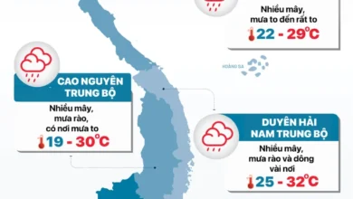
From the early hours through the night of September 18, the stretch from Thanh Hóa to Hà Tĩnh is experiencing moderate to heavy rain accompanied by thunderstorms. General accumulation ranges widely between 20mm and 50mm, with localized, exceptionally heavy downpours exceeding 80mm in isolated pockets.
As the weather system progresses into the night of September 18 through September 19, the core of the heavy precipitation band shifts southward. The area spanning from Nghệ An down to the city of Huế faces heightened risks, with forecasted rainfall amounts generally between 30mm and 60mm. Isolated areas within this zone are expected to record torrential downpours surpassing 100mm, prompting forecasters to flag a high probability of rainfall rates exceeding 100mm within a three-hour window—a threshold capable of instantly overwhelming local drainage infrastructure.
Meanwhile, Northern Vietnam is experiencing a gradual reduction in overall rainfall, though scattered showers and thunderstorms persist. On September 18, Northern provinces can expect localized accumulations of 10mm to 30mm, with isolated spots receiving over 50mm.

Capital Weather: Hanoi Experiences Relief from Scorching Temperatures
In Hanoi, the capital’s weather on September 18 is characterized by cloudy skies, intermittent showers, and thunderstorms. Temperatures are notably moderated by the persistent cloud cover and precipitation, with daily highs maintaining a comfortable range between 27°C and 29°C, while nighttime lows hover around 23°C to 25°C.
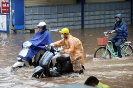
The comfortable temperatures come on the heels of severe weather earlier in the week. Recent meteorological data highlights that Hanoi endured torrential downpours stretching from the evening of September 16 into the early hours of September 17. During this multi-hour deluge, numerous urban districts recorded massive rainfall totals between 80mm and 160mm, with specific stations registering close to 200mm. The intense downpour caused widespread urban inundation, transforming major thoroughfares into river-like conditions and prompting municipal authorities to operate heavy-duty pumping stations at maximum capacity to drain accumulated water from low-lying areas.
Southern Regions, Central Highlands, and Coastal Zones Face Afternoon Storms
While the northern and central regions grapple with continental high-pressure impacts, the southern half of the country experiences distinct tropical convective activities. During the afternoons and evenings of September 18, Southern Vietnam is bracing for widespread rain, moderate to heavy thunderstorms, and localized intense downpours. Accumulations are generally projected between 20mm and 40mm, with extreme isolated events exceeding 80mm.
Concurrently, the Central Highlands region, Khánh Hòa province, and the eastern slopes of Lâm Đồng province are encountering scattered showers and thunderstorms. Rainfall volumes in these elevated and coastal transition zones typically range from 10mm to 30mm, though localized downpours can exceed 60mm.
Looking ahead to the period from the night of September 19 to September 20, the area stretching from Hà Tĩnh to Huế will continue to experience moderate to heavy rain and thunderstorms, with rainfall totals of 20mm to 40mm and localized peaks over 80mm.
Comprehensive Regional Weather Forecast for September 18

Hanoi:
Cloudy with intermittent rain showers and thunderstorms. Winds from the southeast to east operating at force 2-3. Thunderstorms may carry risks of lightning, hail, and strong gusts. Minimum temperatures: 23-25°C; Maximum temperatures: 27-29°C.
Northwestern Vietnam:
Cloudy with scattered daytime showers and thunderstorms; isolated heavy downpours. Nighttime will bring widespread rain and thunderstorms. Winds will remain light, though severe weather phenomena such as squalls, lightning, and hail are possible during storms. Minimum temperatures: 21-24°C (some mountainous areas dropping below 21°C); Maximum temperatures: 26-29°C.
Northeastern Vietnam:
Cloudy with scattered daytime showers and thunderstorms, featuring heavy rain in isolated areas. The plains will experience intermittent showers and thunderstorms with localized heavy accumulation. Winds from the southeast to east at force 2-3. Minimum temperatures: 23-26°C (mountainous pockets below 22°C); Maximum temperatures: 27-30°C.
Thanh Hóa to Huế:
Cloudy skies. The northern sector (Thanh Hóa to Hà Tĩnh) will experience moderate to heavy rain, thunderstorms, and localized torrential downpours, while Thanh Hóa itself will see scattered showers and storms. The southern sector will experience scattered daytime showers transitioning to moderate-to-heavy rain and thunderstorms by evening and night. Winds light, with potential squalls and lightning. Minimum temperatures: 23-26°C; Maximum temperatures: 28-31°C (southern areas occasionally exceeding 31°C).
South-Central Coastal Region:
Partly cloudy with isolated showers and thunderstorms. Afternoon and evening hours will see scattered showers and thunderstorms with heavy downpours in isolated areas. Winds light. Minimum temperatures: 23-26°C; Maximum temperatures: 30-33°C (some areas above 33°C).
Central Highlands:
Partly cloudy with isolated showers. Afternoon and evening periods will bring scattered thunderstorms with heavy localized rainfall. Winds light, with severe risks of tornadoes, lightning, hail, and strong gusts. Minimum temperatures: 20-23°C (isolated areas below 20°C); Maximum temperatures: 29-32°C.
Southern Vietnam:
Cloudy with isolated daytime showers; afternoon and evening will witness widespread moderate-to-heavy rain and thunderstorms, with localized torrential downpours. Westerly winds at force 2-3. Minimum temperatures: 24-27°C; Maximum temperatures: 29-32°C (some areas exceeding 32°C).
Ho Chi Minh City:
Cloudy with occasional daytime showers. Afternoon and evening will experience sustained rain, moderate-to-heavy thunderstorms, and intense localized downpours. Light variable winds. Minimum temperatures: 24-26°C; Maximum temperatures: 31-33°C.
Macroclimatic Context: The El Niño Influence and Winter Outlook
Meteorological analysts note that these seasonal precipitation events occur against the backdrop of shifting broader climatic patterns. Recent long-range outlooks indicate that El Niño conditions are projected to maintain significant strength extending into early 2027. This sustained oceanic and atmospheric phenomenon typically results in weaker-than-average winter monsoon activity across Southeast Asia. Consequently, climatologists suggest that traditional periods of intense cold snaps, frost, and prolonged winter chills in Northern Vietnam may arrive later than usual this season, altering standard agricultural planning and energy consumption models.
Disaster Preparedness, Public Safety Warnings, and Infrastructure Implications
Given the persistent accumulation of water across multiple watersheds and urban centers, disaster management agencies have reinforced public safety warnings. Residents residing in low-lying urban sectors, industrial zones, and flood-prone neighborhoods are advised to clear drainage pathways and prepare for potential flash flooding.
Furthermore, authorities emphasize the severe threat posed by flash floods along small rivers and streams, as well as destructive landslides along steep mountainous slopes in the northern and central provinces. Civil defense teams remain on high alert across key provinces to monitor reservoir levels, manage urban drainage systems, and deploy emergency response units should weather conditions deteriorate further. Citizens are strongly urged to monitor official meteorological broadcasts regularly and avoid unnecessary travel during peak thunderstorm activity.